Závišín - Hvožďany - St. Smolivec - Metly
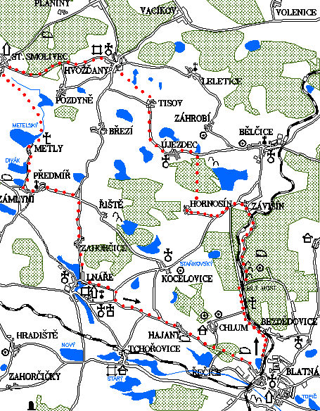
0.0 km
Set off straight across the J. P. Koubka square to the health centre. Turn left. At the crossroads at the railway crossing turn right onto the road towards Bělčice. On your right there will be the railway line and the Závišínský stream. Go past the crossroads showing way to Bezdědovice (right) and Chlum (left). The traffic might bother you a bit because this road is used by drivers travelling to Prague. Soon, you will reach the edge of the forest. There, after a few hundred meters, turn righ onto a forest path. Right at the turn there are quite well-preserved prehistoric gold-panning sites, beginning in the cadastral area of the village Závišín to the cadastre area of the village Bezdědovice. Cross the railway carefully and just behind it there is a nice, recently repaired stone bridge over the Závišínský stream. It is called the Bílý most (White Bridge).
4.9 km
Behind the bridge there is a crossroads. Turn left along the Závišínský stream. The forest path is often muddy, so it is hard to imagine that about forty years ago there was a road leading to Závišín. Until recently, there was a road sign reminding those times, but it too gave way to nature. Today, however, the advantage is that there are no streams of cars along the way and we can enjoy the views of the landscape. This valley of the Závišín stream blongs among the most beautiful parts of the Blatná region.
7.0 km
Lopatárna is an old factory situated at the mill race. The building of the factory including farm buildings has been preserved but unfortunately, the formerly representative residential house is falling apart. Until recently, people still lived there. Lopatárna is secluded but it is not far away from the well-preserved building of the Závišín railway station. From there it is still quite a long way to Závišín itself. There is a memorial to the victims of the 1948 disaster at the railway crossing.
Závišín
In 1430 a court was mentioned here which belonged to Přibík of Švihov, later the village belonged to the Lnáře manor.
8.2 km
Závišín is a picturesque village situated on the bank of the Závišínský pond. At the crossroads at the chapel turn left and after a moment you will arrive at the crossroads with the main road to Blatná. However, after two hundred meters, turn right onto the road towards Lnáře. After a moment turn right towards Hornosín. You will climb up a hill to the village.
Hornosín
In 1528, the village belonged to Zdeněk Běšin of Běšiny, in the 17th century it was already a part of the Lnáře manor. The Chapel of St. Florián is from 1860. In 1884 almost the whole village burned down. At the beginning of this century there were 35 houses with 200 inhabitants.
10.6 km
In Hornosín, near the chapel, follow the yellow tourist trail to the right. Go along the dirt path alternately downhill and uphill. There will be fields and meadows around you, sometimes forest. It is a pleasant journey.
12.3 km
The yellow trail turns left under the Kněžská hill and leads up the hill along an impassable road. Continue, therefore, straight on through the forest with terrain more suitable for cycling. The road will lead you out of the forest to an asphalt road. There turn left and after a few hundred meters you will arrive in Újezdec.
Újezdec
In 1362 it was a parish village where Jan of Újezdec resided. Between 1401–1414 Újezdec belonged to Oldřich Slepec of Miličín. The Church of St. Vorshila is a Romanesque-Gothic church from around 1250. At the church there stood a fortress with a malt house and a brewery which disappeared after 1542. Gold was mined and panned in the area in the 14th century. King Jan pledged the local mines to Petr of Rožmberk.
13.6 km
From Újezdec continue on the road to Tisov. The yellow trail leads along the road.
Tisov
It was first mentioned in 1318, maybe there was a fortress. After 1617 the village belonged to the Lnáře manor. In 1654 there were only three cottages, the mill was mentioned in 1542.
16.0 km
In Tisov continue on the yellow trail. It will lead you from the road onto a dirt road. It is a rather difficult way. For those who want a more comfortable way, it is possible to continue on the road from Tisov. It goes parallelly and ends at the same spot – the village of Hvožďany. However, the yellow trail will lead you to the church in Hvožďany. The church is worth the visit ( see trail no. 9).
17.9 km
In Hvožďany continue straight on across the square along the red tourist trail towards Starý Smolivec. Behind the village, the red trail turns right onto a dirt road leading to the Třemín forests. However, you have to continue along the road. Go past the turn to Pozdyně and continue straight on. The road goes through the forest and between meadows with a lot of views. On your right you will see the Třemšín hill.
Starý Smolivec
Until 1559 the village belonged to Bezděkov. In 1608, Ondřej Řesanický of Kadov is mentioned in the fortress in Smolivec. After 1697 th village with its chateau and court was sold to Jiří Vojtěch Janovský of Janovice and attached to Oselce. The chateau is from the Baroque period, from the beginning of the 18th century. There used to be a brewery with the chateau. In 1720, there were three farmers, six cottagers, a tannery, a gamekeeper‘s lodge and a sheepfold. On October 7th 1620, the back troops of the imperial army and the Estats‘ troops clashed between Starý Smolivec and Radošice in the “Vražda“ (Murder) meadow.
22.3 km
In Starý Smolivec turn left at the first junction. You will join the blue tourist trail. It will lead you to the left, off the road. Continue along the dirt road, through a nice flat landscape between meadows and ponds. Soldiers who died at the battle between the imperial and Estates‘ troops are buried on the dam of the Metelský pond under the stone cross.
Metly
The village belonged to the manor of Lnáře, apart from the period between 1564–1677, when it was a part of the Blatná manor. In 1684 there were eleven houses. In 1675 the whole village burned down.
26.1 km
You will return to the road in the village of Metly again. Continue along the blue trail. After a moment you will arrive in Zámlyní where there is a legendary stone “Zkamenělá kráva“ (Fossilized Cow).
Zámlyní
There was a mill here already in the 14th century, in 1695 there were three cottages and two mills in Zámlyní. Under the Divák pond, there were iron works in the 18th century.
27.6 km
At the chapel turn left onto the road towards Předmíř. The blue trail goes straight on, pass through the village of Předmíř and continue through the open landscape. After several kilometres you will arrive at the junction with Lnáře.
29.5 km
Turn right and after two hundred meters turn right again. The journey is comfortable – flat and on the road. Go through the village of Zahorčice. Behind the village, the road is nice, and you will be able to see the reconstructed church at the edge of Lnáře. You will arrive in Lnáře near the dam of the pond.
32.8 km
In Lnáře, do not cross the bridge over the dam towards the centre of the town, you can see it along trail no. 3, but turn left up the hill. Soon, you will be out of Lnáře. Up the hill, at the junction, turn right, seemingly back to Lnáře but after four hundred meters turn left onto the road to Hajany. You will have to climb for a while. From the top of the hill you will have a nice view towards Blatná. Go down the hill to Hajany.
37.0 km
You cannot get lost on the way from Hajany. Continue on the road, and without any major ascents or descents you will get back to the starting point – the centre of Blatná.
41.6 km
Blatná – Tower
Natural points of interest of the 2nd trail
The first third of the journey leads upstream of the Závišínský stream which springs on the slopes of Třemšín and serves as a source of drinking water for Blatná. The reservoir of water is mainly the Huťský or Velký bělčický pond below Bělčice where farming is limited. The tapping point of the water treatment plant is above the village of Bezdědovice. The stretch of the Závišínský stream between Závišín and Bezdědovice is also a naturally valuable exmaple of a natural forest creek lined with vegetation more typical for the Brdy region where the stream springs. Covers of primroses, anemones, lungworts and other flowers can be seen from the romantic White bridge under which trouts float and grey wagtails, rarely also common kingfishers and in the winter also white-throated dippers fly. A white stork nests on the high chimney of Lopatárna near Závišín, another type of nest is on a lower chimney on the homestead in the middle of Hajany.