Surroundings of rocking stone
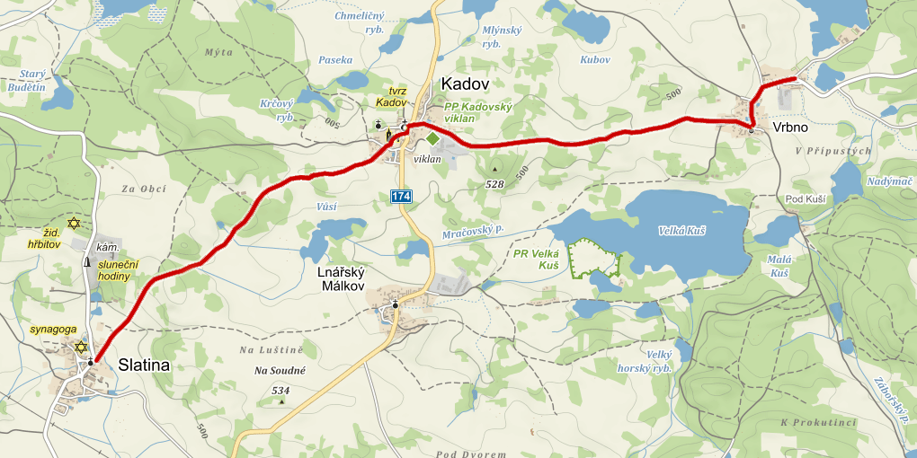
The nature trail in the surroundings of the rocking stone (granite stone weighing 30 tons, the largest in Bohemia) leads between the villages
of Vrbno, Kadov and Slatina. On route you can learn about the history of Kadov and its neighbouring villages, you will get to
know the fauna and flora of this landscape and will get acquainted with fish farming in the Blatná Basin. The starting point
of the trail is in the vicinity of Vrbno at the Velký Pálenec pond. From there it leads through Vrbno to Kadov and to the
village of Slatina.
Download GPX file with the rout
e (source: Tourist portal CZeCOT.cz)
Hydrobiological station Velký Pálenec
-
Hydrobiological station Velký Pálenec, which was established by professor Karel Schäfferna in 1925 in the building of the former gamekeeper‘s lodge is a detached workplace of the Faculty of Science of the Charles University in Prague. It came after the „flying“ (portable) field station of professor Frič established in 1888 which was one of the oldest such stations in Europe. The foundation of the actual building is much older, after all, in 1883, the mother of the writer Ladislav Stehlík, who is the author of Země zamyšlená, was born here.
-
The forest
In the distant past, forests covered almost the entire present territory of the Czech Republic. Because of the gradual use of land for other purposes, the area of the forests decreased and at present has stabilized on one third of the area of the Czech Republic. This is an above-average figure among European countries. Since the beginning of the last century the area of forests has been increasing. Forests are one of the most important elements of ecological stability of the landscape. The development of the human civilization has influenced forests, too. Species composition of trees has changed.
-
Amphibians
Gradual overgrown banks and warm waters of smaller ponds form an ideal habitat for the development of amphibians. Such ponds are, for example, just a few meters away from us, the Žabinec pond, the nearby Malý Pálenec pond and the Žoldánka pond.
-
Vrbno, Mračov
"The village of Vrbno certainly has its name from the willows. It belonged to the estate of the monastery of St.George in the Prague Castle already in the 13th century and in exchange it got to a Kold in 1305. (Contributions to the History of Administration and Municipality of Vrbno, Jan Pavel Hille).
-
Fish farming
The first ponds were built as protective elements of the local forts. Since the 14th century, when Charles IV ruled, that have been built for fish farming. It is stated in the Charter of Charles IV that building ponds had several meanings: to make sure there was abundance of fish to feed people, to withdraw water from marshes and swamps, to maintain the beneficial effects of water evaporation, to retain excess water and prevent flooding, to drive mills.
-
Rock basins in granite stones
If you follow the nature trail from this sign towards the forest, after about 100 meters you will reach a hill named Hora. At its peak there is a triangulation point marked with a red pole. About 200 meters westwards from this point lies a large granite boulder which has two bowl-shaped depressions on its top.
-
The rocking stone
A rocking stone in general is a rounded rock block or boulder that touches the ground only with a very small part of its surface. The real rocking stones are those „in situ“ i.e. those which were made in the place where they are today and not removed. The development of a rocking stone is explained by selective erosion and rock removal processes. Some of them were probably formed by two-fase weathering just like so called Čertovy náramky (Devil´s bracelets) and Obětní kámen (Sacrificial stone) where the stops number 11, 12 and 13 of this trail are located.
-
Kadov
Kadov is mentioned as Kádovský dvůr in 1352. The surname Káda originated from the generic word kada which means a pot. The village is still part of the Blatensko region – so it belongs to the South Bohemian region but further to the west the ponds are gradually replaced by elevated hills and views of the Šumava foothills and the whole Šumava mountains open to us. When the weather is good, you can enjoy a beautful view of the Šumava forest above the village Lnářský Málkov near the road leading to Svéradice.
-
The chapel and the tomb
The foundation stone of the Nalezení Sv. Kříže Chapel was laid on 25th April 1856 by Count Václav Lincker from Lutzenwick. The chapel was built in neo-gothic style and was completed and consecrated in 1863. Its ground plan is cross-shaped. Previously, several times a year, Holy Masses were served.
-
View of the countryside
The place where we are now provides us with a view to the north – the Brdy Highlands. A distinctive silhouette outlined on the horizon is the Třemšín Hill (827 m) which is the highest point of the southern part of the Brdy Highlands. The name of the Třemšín hill is probably derived from three golden rods sunk in the castle well. The hill was also called „The king of the Brdy forests” by Jaroslav Vrchlický. The Třemšín Nature Park was established in 1997 in the surroundings of the Třemšín Hill.
-
Malý čertův náramek (Little Devil‘s Bracelet)
"There was a young teacher at the Kadov school many years ago. He taught conscientiously and the children liked to listen to him. One day he was telling them something interesting when a boy in the last row suddenly cried: „Devil!“ There stood a black horned creature which showed the teacher to go out...“ (From the book Čertovy kameny by Jiří Sekera )
-
Obětní kámen (Sacrificial stone)
It belongs among other mysterious structures of the Kadov region. You can find the stone if you walk along the forest path for approx. 200 m and then continue over the edge of a meadow up a wooded hillside. Because of its size, shape, location and especially because there is a rock basin with a more or less developed drainage trough on its upper, almost horizontal surface, it was considered by local people and some archaeologists to be a stone which used to serve for pagan sacrificial ceremonies. Today we know with certainty that the boulder and the basins are the work of nature, but if it ever served some mysterious rituals is still impossible to prove or confirm.
-
Velký čertův náramek (Big Devil‘s Bracelet)
A group of boulders which can be reached on a marked forest path after approx. 200 m is called Velký čertův náramek or Čertův cestovní vak. Rounded boulders of different sizes spread over a 28 m perimeter rise up to 6m. On their surface they are covered with dark weathered bark. You already know from the previous information boards how these bizzare stones were formed.