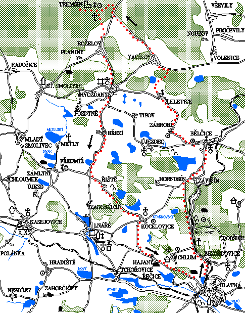
Záhrobí - Třemšín - Hvožďany - Kocelovice
0.0 km
Set off at the square J.P.Koubka and go straight ahead towards the health centre. There turn left until you reach the intersection with the main road. Then turn right towards Bělčice. You will go past two ponds: on the right side Pustý rybník and on the left side Podskalský rybník. Then go past the village of Bezdědovice.
3.5 km
Keep still on the road. Occasionally there may be increased traffic - it is the main route from Blatná to Prague. However, the road leads through a beautiful dense forest. Unlike in the 5th trail, do not turn right onto the Bílý most (the White Bridge), but continue straight ahead.
10.1 km
In Bělčice on the square turn left along the road towards Újezdec. Stick to the green trail. At the crossroads, which is close to Bělčice, continue along the green trail to the right. On the left side of the hill there are quadrangular ramparts (Nemethon) delimiting the sacred space of a Celtic shrine from the 2nd century BC. They were also used by the troops before the Battle of White Mountain in 1620. Then you arrive at the village of Záhrobí.
12.4 km
Right on the outskirts of the village turn right on an unpaved road and go uphill. The green trail continues straight along the road. In the fields behind the village, not far from the forest, you will arrive at a crossroads with a wooden cross.
13.3 km
At the wooden cross turn left. The red trail leads in the same direction and it will lead you to the village of Leletice.
14.7 km
Go through the village and turn right to the secondary road. Pay attention that the main road goes straight, and the red sign too. Climb up and on the right you will see holiday huts. You will reach the crossroads through the forest. There turn left to Vacíkov.
18.9 km
In Vacíkov there is an important crossroad. The main road leads to Hvožďany. You will leave it and turn right. But beware, the road with the yellow trail turns even more right from the same place which you shall not follow. Climb up a narrow road. You will be heading towards Třemšín peak through a nice deep Brdy forest.
22.6 km
You will get to the crossroads of Na Dědku, where there is a monument to two gamekeepers - a father and a son who helped partisans and were shot by the Nazis. At the gamekeeper's lodge there is a summer children's holiday camp. Cross the main road and continue along the red trail to a long climb. Stick to the narrow road, or rather its remains, because the red trail sometimes leads through steep shortcuts. You will get to the intersection at Gangloff's Cross.
25.6 km
Cycle or walk toward the top. The steep climb will take you to the forest chapel and around it to the very top of Třemšín at a height of 827 meters above sea level.
26.4 km
Go back to Gangloff's Cross where you turn right along the red trail, along the same road that you arrived on. The way down is bumpy and rumbling. After a while you will arrive at the crossroads, where the forest road meets with 3 roads. The one on the right would lead you back to Třemšín, the left one is the one you originally arrived from the Na Dědku crossroads (red trail). Take the road down to Roželov. Above Roželov leave the forest and you will have a beautiful view of Blatná. When you arrive at the main road, turn right.
30.3 km
In Roželov turn left along the road towards Hvožďany. Keep going down. You deserve it, because the long climb to Třemšín was certainly exhausting.
33.1 km
You will reach the pub in Hvožďany where you can relax and refresh. On the tap they have a good and cold Gambrinus. Continue along the pub towards Březí and then go through the village.
38.0 km
At the end of the Křepín pond, which is on your right hand, turn left to Říště. There are two turns in a row. Always head left. Just after a short climb you will get to the village of Říště. Cycle through and continue via the flat pond landscape along a high-quality road to Kocelovice.
42.7 km
At the pub in Kocelovice turn left to Hajany. On the way you will pass an intersection. The road on the right climbs to Lnáře. However, you will descend left to Hajany.
49.9 km
Blatná – Tower
Natural points of interest of the 9th trail
Behind Zahorčice, on the left under the crossroads of roads, there is a 1.6-hectare natural monument Pastvina u Zahorčic between fields and meadows. Plant communities of wet and drier pastures were mostly devastated by amelioration, ploughing or fertilizer runoff, with the exception of protected areas today. As pasture has disappeared in the past decades, these protected areas must now be mowed according to the strict instructions of the State Nature Conservation Authority, so they don´t overgrow with trees and shrubs. Tourists are forbidden to enter beyond the borders of natural monuments and reservations, the borders are marked with the national emblem and a double red stripe on the trees or stilts. As you go to and from Třemšín, keep on paved paths, do not cycle off nor take shortcuts as you would contribute to erosion. Especially on the top parts of Třemšín, spruce forests pass into original beech forests, and fir is also common. A rare bird in the Brdy forests is the black stork, nesting in deep forests and eating mostly fish from streams. On the slopes of Třemšín springs Závišínský brook (see 2nd trail). On the way to Třemšín it is possible to notice changes in plant communities to typical mountain species.