Tchořovice - Hadí rybník - Jindřichovice - Mačkov
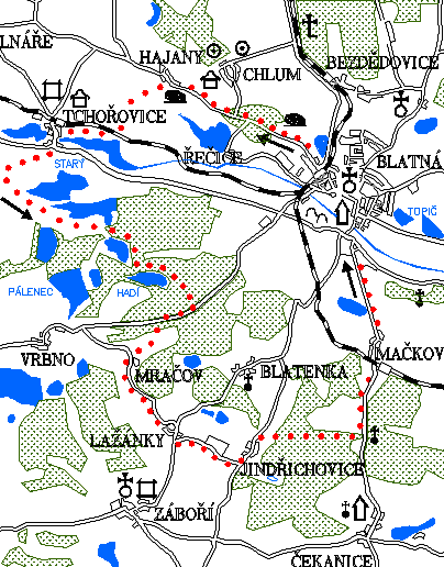
0.0 km
Set off at the square J.P.Koubka, go straight on to the health centre, where we turn left. You arrive at the crossroad, on the right there is a road to Bělčice and Prague, on the left back to the centre of Blatná, go straight on across the railway crossing towards Hajany. On the left go past the area of the former arms factory. On your left you will see a big quarry and you will soon enter a forest.
3.0 km
On the right, the road turns to the village of Chlum. Near the crossroads is flooded quarry with clean and cold water. Continue straight ahead until you reach the village of Hajany.
Hajany
It was first mentioned in 1393, since the mid-16th century it has belonged to the Blatná estate. In 1700 there were 9 houses, 1 cottage, pub and mill. The chapel is from 1900, along the stream there are remnants of mounds created while panning gold. Above the village is Zbiroh hill, 481 m high.
4.6 km
In front of the chapel turn left and follow a nice unpaved road towards Tchořovice. After the railway crossing turn right and continue along the track to Tchořovice. On your left will be a large Dolejší rybník (the Lower Pond).
7.4 km
At the station in Tchořovice (see the 3rd trail) turn down the main road. Cross the bridge and turn to the fortress. Go back to the main road and continue along it. Immediately turn right onto the road towards Hradiště. Do not go up a slight climb to Hradiště, but in the village go uphill towards the backup military airport. Cross both wide concrete runways and follow a narrow road that leads to a group of ponds. At their edge there is a small duck farm. The asphalt surface ends there and you will continue along the often muddy unpaved road. The landscape around is really beautiful. Enter the forest where there are more ponds on the right. After a while you will arrive at an intersection located deep in the forest. There begins the asphalt road again. Go straight along it through a nice dense forest. At the edge of the forest you can see a view of the Velký Pálenec pond.
10.3 km
Do not follow the path towards the pond, but turn left along the green hiking trail towards Hadí rybník (the Snake Pond).
11.1 km
Swimming in Snake Pond is really pleasant and there is even a slide. Refreshed, you can continue cycling along the pond. The green trail turns left onto the forest road, but go straight on to the road until you reach the main road.
12.1 km
At the crossroads turn right as if from Blatná. At the first nearby intersection turn left towards Mračov. When you get down you will immediately have to go up a steep hill. Fortunately, it is a short climb. Do not enter the village of Mračov, but turn right, after a few meters there is a crossroad with a wide asphalt road. Then turn left uphill. Be ready for a long climb up to Lažánky.
Lažánky
The first records of the village date back to the 13th century, when it belonged, like several other villages, to the St. George's Convent. In 1770 there were 16 houses. The chapel from 1884 on the village square was a valuable monument until recently. There was also a very lively pub.
14.7 km
Right before the edge of the village turn right uphill (if you went straight on, you would go downhill but it would be longer). Go through the village and turning around the bus stop you will get back to the main road. After a few meters turn left onto the road and you will climb up again. There will be a big cowshed to your left. Cross the hill and go down to Jindřichovice.
Jindřichovice
They are mentioned already in 1228, since the 16th century they belong to the Bratronice estate.
16.4 km
Descend through the village from a relatively steep hill. Be careful not to run over a hen or a dog. Just outside Jindřichovice, the road is almost flat. Turn right onto the narrow road and climb slightly. At the edge of the forest turn left, still along the narrow asphalt road. And then enjoy the ride, because this part is very nice. Forests, hills, descents, ponds, meadows. The only deficiency of the trail is that it is not longer.
19.2 km
You arrive at the junction with the road from Čekanice. There is a flooded former quarry. It used to be a great place for swimming but today the whole area is fenced. Go downhill to Blatná basin. Then go through the village of Mačkov and then on the long straight back to Blatná.
22.9 km
Blatná – Tower
Natural points of interest of the 6th trail
The trail probably passes through the most beautiful pond system between Tchořovice and Vrbno (see 4th trail). Numerous species of waterfowl nest here: warbler, buntings, locustellas and you can also find a nest of penduline tit. Above the ponds, fields and meadows hunt slender predators. Near Velký Pálenec is a hydrobiological station of the Faculty of Science, Charles University. Rather a recreational Hadí rybník (the Snake pond) got its name from the common grass snake. Ponds in the vicinity of Vrbno, together with the forests around Mračov and Jindřichovice, should be declared a natural park as a harmonious and still little disturbed example of the typical Blatná landscape. Behind the pond Smyslov there is a protected natural monument Smyslovské louky protecting wet meadows and boulder pastures with orchids, pedicularis palustris and nesting grounds of meadow pipit and whinchat.