Řečice - Vrbno - Kadov - Bezděkov - Pole
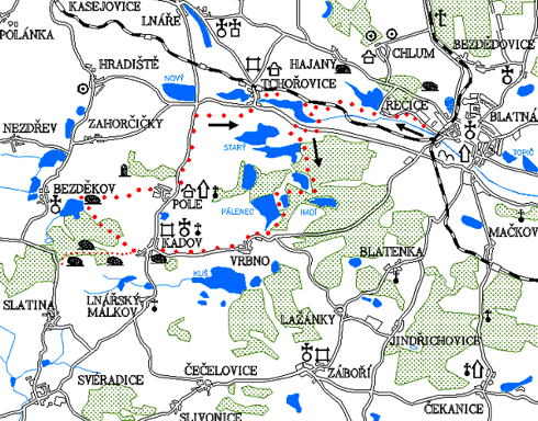
0.0 km
Set off across the square of J. P. Koubka, at the end of the square turn left and go through the class T.G.Masaryk. Turn left at the Sokol house - blue tourist trail. After a while, detached houses on your left will be replaced by the Blatná game park. At the first intersection, do not turn left along the bridge over Lomnice, but continue straight along the blue trail along Lomnice. On the right you will pass the grain silo and quarry. The first houses were built in Blatná sometime in the 18th century.
2.8 km
From Řečice continue along the blue tourist trail. It will lead you from the road to a bumpy unpaved road. Fortunately, the route is flat - between fields and meadows along the railroad. After a while you will cross the track and have it on the right hand. Then you reach the mill, at the crossroads of unpaved roads. On the right across the railway line there is an unpaved road uphill to Hajany. If you went straight on following the blue trail, you would arrive at Tchořovice. However, you will head left on the dam. The road is not very good after heavy rain. There are many muddy places. It will lead you to the main road.
5.9 km
When you get on the road, turn right. The road surface is pretty smooth and nice to cycle on. Unfortunately, there are also many trucks which is quite unpleasant. Therefore, at the first opportunity (after about 800 meters) you will leave this motorcyclists paradise and turn left to the unpaved road. There you will see the blue tourist track again. In the final stage, before turning off the main road (about 50 meters), it is important to watch out for passing cars but it is also worth looking at the left road ditch. On its edge there is a commemorative cross from 1827. However, in the summer it is usually hidden in nettles. Then follow the blue trail through a nice landscape. There will be forests and ponds. You will follow the forest paths to the Snake Pond (Hadí rybník), where there is a small recreation centre and a place for swimming with a water slide.
9.0 km
When you reach the pond, turn right along the road still following the green trail. It will lead you along the dam of the Velký Pálenec pond. You will go past the summer camp for children and get to the village of Vrbno. The village Vrbno originally belonged to the monastery of St. George at Prague Castle, from the 15th century it was part of the manor house Lnáře. There are some of the most beautiful ponds of Blatná region (Velká Kuš, Pálenec, Hadí, Vitanov, Smyslov). In the 19th century, there were attempts to mine coal near the village.
11.7 km
In Vrbno leave the green trail and continue on the road towards Kadov. Be ready for a slight climb. The road leads a lot through the forest. Then you arrive in Kadov. The famous rocking stone is right on the edge of the village, on the left side on an overgrown hill just behind the premises of the agricultural cooperative. If you have enough time and strength, it would be a great mistake not to go through the nature trail along the bizarre stone formations around Kadov. It starts with a rocking stone and ends with "Devil's bracelets". The length of the trail is about 5 km.
Kadov
In the years 1360–1380 Kadov was owned by Racek with his brothers with a wheel in coat of arms. Přibík of Kadov was told that in 1421 he shot Žižka in his only eye in front of Rábí. The present appearance of the originally medieval fortress is from the late 16th century with rich Renaissance volute gables, at the end of the 18th century, transformed into a granary. The church of St. Wenceslas, originally early Gothic, was rebuilt in the second half of the 18th century in the Baroque style. Around the church is a cemetery with old tombstones from the 16th century. The parish building from the mid-18th century is one-story with a mansard roof. Near the church is a neo-Gothic tomb of the Lineker family from 1859–1860. Interesting is also the house no. 38, a former poorhouse from 1656 with a granite portal and alliance signs above the entrance. There are numerous granite stones in the surroundings of Kadov. Apart from the most famous rocking stone there is another which is said to have served for a rest of St. Vojtěch.
14.4 km
At the top by the parish church follow the road to the left around the fortress. The road on the right would lead you only to the cemetery, where there is an interesting Neo-Gothic tomb. At the first crossroads, take the asphalt road to the right. This will lead you to the end of the village. There follow the unpaved road to the right down the slope. Cycle past a tent camp on the bank of a pond situated in the middle of a forest. After a while you will get out of the forest, go down the hill to the dam of Velký Bezděkov pond. Turn right along the dam. At the end of the dam, there is an unexpected surprise. An almost three-meter-high stone figure will gaze at you from a small hill between the pines.
17.0 km
From the stone figure continue along the pond. On the left side, right on the bank of the pond, there is a low stone commemorative cross. It is usually completely hidden under a high nettle. If you have long sleeves you can locate it roughly in the middle between the metal feeding equipment of the fishers and their wooden hut.
Bezděkov
Already in the 13th century there used to be a fortress, later rebuilt into a chateau. After Bezděkov was added to the Lnáře manor, the chateau was rebuilt into a granary. In the village there is an early Gothic church of St. Andrew from the late 13th century, modified in the 16th and 18th century. Half of the village burned down in 1735. The mill under the village stood there already in 1603. On the way to Hradiště there used to be a plague cemetery. Turn right onto the unpaved road, uphill towards the forest. On the top of the hill you will be rewarded for climbing with beautiful views of Lnáře and its neighbourhood and further towards Třemšín. Head down via a bumpy unpaved road to the village of Pole, which lies directly below you. The first mention of the village Pole dates back to 1233. A Renaissance chateau with rich gables was built on the site of a former fortress at the end of the 16th century. The chapel on the square is a pseudo - Gothic building from 1926. An interesting monument is also the log house no. 2 and there is also a specific building of a pub – farm.
20.4 km
Go past the famous rock pub down the road. At the intersection with the main road turn left towards Tchořovice. The path leads through a nice rolling landscape. The road has a quality surface, so cycling will be quite enjoyable. We will cross two long concrete runways of the reserve military airport. If you cycle on the airport runway you can be in Tchořovice faster than on the road. You cannot get lost because the village will lie in front of you like on the palm of your hand. In Tchořovice head left on the main road uphill towards the station.
25.0 km
From the station follow the blue trail to the right. Behind the village, at the end of Dolejší rybník (Lower pond) by the mill, at the crossroads of field roads, turn left uphill across the track. If you turned left, you would go back the same way you have gone before. Behind the track go down the unpaved road to the village of Hajany. There turn right on the road to Blatná.
32.3 km
Blatná – Tower
Natural points of interest of the 4th trail
The way from Řečice leads around Hajanský rybník with a colony of nesting seagulls. Then you pass through meadows with beautiful scattered willow trees to Dolejší rybník. On its southern bank under the main road lies the 6 hectare nature reserve Dolejší rybník protecting a wetland with rare peat-marsh land flora. In an inaccessible marshland can be spotted, for example, a bog bean, a carex diandra, and other rare plants, which must be protected by nature conservationists against the overgrowth of willows and alder trees. Before entering the forest, there is a path along the Radov dam, which is the most important gathering place of water birds in the Blatná region. Especially in August and during the spring and autumn, there are up to several thousands of waterbirds staying there on some days: wild ducks, black coots, aythya fuligulas (with white flanks), swans, common and blue teals, Anas clypeata, Podiceps cristatus, Black-necked Grebe and Small Grebe. Resting on the stones in the middle of the pond can be seen cormorants, terns and other bird species. A very interesting geological peculiarity in the village of Kadov is the natural monument Kadovský Viklan (rocking stone), whose re-installation into a rocking position (from which it was removed at the beginning of the century) was arranged by the well-known engineer from Strakonice Pavel Pavel. Behind Tchořovice Airport there is a path along the dam with old oaks between the Nový and Hořejší Pond Reservations (see 3rd trail).