Tchořovice - Kasejovice - Lnáře
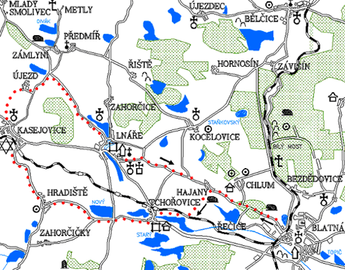
0.0 km
Set off at the square J. P. Koubka, go straight on towards the health centre, where we turn left. You arrive at the crossroad, on the right there is a road to Bělčice and Prague, on the left back to the centre of Blatná, go straight on across the railway crossing towards Hajany. On the left go past the area of the former arms factory. Behind Blatná on the left you will see a large quarry and you will get into the woods soon.
3.0 km
On the right, the road leads to the village of Chlum. Near the crossroads there is flooded quarry with clean and cold water. It is perfect for swimming. Continue straight ahead until you reach the village of Hajany.
4.6 km
At the chapel turn left and follow a nice unpaved road towards Tchořovice. Behind the railway crossing turn right and continue along the track to Tchořovice. On the left you will see a large Dolejší rybník (Lower Pond).
7.4 km
At the station in Tchořovice go down the main road. Cross the bridge and turn to the fortress.
Tchořovice
In 1321 the courtyard belonging to the Strakonice castle was first mentioned. Then a fortress was built here, where Jan of Tchořovice resided in 1372. In 1409 it was held by Vilém of Zvířetnice. Tchořovice changed owners several times before the indebted estate was sold in 1653 to the Lnáře manor. The fortress is a two-story building around a square courtyard. The remains of medieval masonry in the cellar of the fortress, which was used as a granary in 1675, prove its foundation in the 14th century. There are more detailed reports about the settlement itself from the 17th century, according to which it burned several times. In 1654 there were 26 houses and 288 inhabitants. On the square there are farmhouses no. 10 and 12 from the middle of the 19th century.
Then return to the main road and continue along it. However, immediately turn right onto the road towards Hradiště where you will go slightly upwards. There is the Hořejší rybník (Upper Pond) on the right and a field on the left. Behind it there is a backup military airport. After about two kilometers you will reach a crossroad.
9.4 km
The road on the right leads to Lnáře and on the left uphill towards the village Pole. Go straight towards the village of Hradiště. After a while you come to another intersection, where you turn right to Hradiště. The road leads through a nice apple alley.
Hradiště
It is one of the oldest villages in the Blatná region which was owned by St. George's Convent in Prague, in the 13th century. In 1456, the whole village and the backyard belonged to Lnáře. There used to be a fortress, later rebuilt into a granary and a brewery. There were several mills, the oldest mentioned as early as 1442. Near the village there is an important prehistoric burial ground with flat fire graves from the earlier La Tene period.
12.2 km
At the beginning of the village you will have to climb for a while. At the top of the hill on the left is a burial ground and a fortified settlement from the Bronze Age. At the crossroad by the church turn right to Kasejovice. You will cycle through rolling countryside, between fields, meadows and forest. Cross the railway on the outskirts of Kasejovice. After the railway turn left until you reach the main road. After it, turn left to the square.
Kasejovice
This village is first mentioned in 1264 as the seat of Zdeslav of Kasejovice and his brothers Noskop and Voislav, whose descendants were the rulers of Frymburk, Střela and Lnáře. In the coat of arms of the rulers of Kasejovice we find two donkey heads as a reminder of their participation in the crusades to the Holy Land. Around 1300 is mentioned Protiva in Kasejovice, probably Zdeslav's son, who built a stone fortress here. In 1308 Protiva II. gave Kasejovice, already called a small town, certain privileges. At the beginning of the 15th century, Kasejovice was held by Anna of Frymburk, the wife of Petr Zmrzlík of Svojšín. After her death the town became part of the Lnáře manor. Church of st. Jacob is early Gothic from the 3rd third of the 13th century, reconstructed in Barroco style before the mid-18th century and rebuilt in 1868, 1892 and newly in 1936. There was a brewery already in 1613. The Jewish community was founded in 1726 and a synagogue was built in 1763. The town had 51 houses in 1622 and 154 houses in 1770. Kasejovice burnt down several times, especially in 1791 and in 1868, when 38 houses burned down. In Kasejovice there was also one of the 13 throat courts in the Prácheňský region. In the surroundings of Kasejovice were mined gold and silver in the 15th and 16th centuries, and a more recent mining history dates back to the 18th century. Attempts at gold mining were repeated after 1904, especially at the Jakubská shaft.
15.9 km
From the square go along the church following the blue tourist trail. You will have to climb a steep hill on a rocky unpaved road. After some time, you will reach the hill above Kasejovice. There is a very nice view. At the top of the hill turn left along an unmarked unpaved road towards the residential house. Behind it there is something like a grove. Behind the wall, however, hides a relatively large and well-maintained Jewish cemetery. It has a nice view towards Třemšín. Then return to the blue trail and take a relatively steep descent along a bumpy unpaved road towards Újezd u Kasejovic.
Újezd u Kasejovic
The first mention of the village dates back to 1395, when the village belonged to the important family of the Zmrzlíkové of Svojšín. There probably used to be a yeoman fortress too. The Jewish cemetery in Kasejovice is mentioned already in 1669.
18.1 km
Cycle through Újezd and continue along the blue trail. After a long descent you will reach the crossroads. On the left, the road leads to Mladý Smolivec, straight to Zámlyní. However, you will turn right to Lnáře. There is a flat and quality road to Lnáře, so you will be there in a while.
22.7 km
On the left side of the town there is a renovated church. Continue straight ahead until you reach the intersection with the main road to Nepomuk. Behind the intersection there is a monument to the fallen American soldiers.
Lnáře
In 1318 Habart of Lnáře is mentioned, later the castle and the settlement are held by the important family of the Zmrzlíkové
of Svojšín. Zdeněk of Šternberk bought Lnáře in 1564 and in 1575 he transferred it to Volf Novohradský of Kolovraty,
who enlarged the estate by buying several villages and also rebuilt the original Gothic castle in the Renaissance style at
the turn of the 16th and 17th centuries. The Early Baroque Lnáře Chateau is from around 1670. The builders were the then
owners of the estate Aleš Ferdinand Vratislav of Mitrovice and after him Humprecht Jan Černín of Chudenice. During the
reign of the Černínové of Chudenice a monastery of Discalced Augustians was built between 1688 and 1693. The early Baroque
four-wing single-storey building is the work of architect G. B. Maderna. Part of the monastery was the Church of the Holy
Trinity, built in 1666–1723 on the site of a former hermitage.
In 1735, when the estate was owned by the German Künigl family, the cemetery church of st. Nicholas replaced the original
Gothic church from 1356. The Lnáře Chateau came into history during the period of anti-statute labour resistance in the
Prácheňský region in the 18th century. In 1738, those who refused to accept statute labour were physically punished in
the courtyard of the chateau with military assistance. Since 1745 the Lnáře estate had a new owner, the Earls of Sporck,
who owned Lnáře until 1802. Crop failure, hunger and poverty were the cause of peasant rebellions in 1771 on the Lnáře
manor. The fate of the village has long been associated with the history of the castle which had many owners. Since 1803 the
manor was owned by Lückner of Lutzenwick, the last owners since 1869 were the lords of Lilgenau.
Turn left - around the castle. On the right you will have Podhájský pond. The road will go up after a while. At the restaurant Pod klášterem, turn off the main road to the left into a steep slope. On your right there will be a complex of monastic buildings. When you leave Lnáře, set out for the undulating landscape. After a while you will arrive at the road junction.
25.0 km
Turn right on a long climb up the road. When you reach the top, you will be rewarded by a nice view of Blatná.
27.6 km
Descend from the hill to the village of Hajany and return via the same route set out from Blatná.
32.2 km
Blatná – Tower
Natural point of interest of the 3rd trail
There are two important specially protected areas along the route. Between Hradiště and the intersection in front of Tchořovice, on the left side there is a natural monument Nový rybník u Lnář (New pond by Lnáře), which has been protected since 1933 as a nesting place for the sea gull. Today on the island in the middle of the New Pond (which is of course forbidden to enter) among hundreds of seagulls nest a few pairs of very rare terns as well as grebes, stag beetles and several species of ducks. Right under the dam of the New pond opens the nature reserve Hořejší rybník (Upper pond), which covers almost 57 hectares. It includes a valuable mixed forest called Bažantnice and the entire pond with extensive rushes and waterlogged alder and wet meadows. Exceptional are large stands of yellow water lily, pond edges are decorated with yellow irises. The reserve is probably the richest part of Blatná, even in the case of birds, among the most precious species are the nightingale bluebird, marsh harrier, water crake, and the great spotted woodpecker nesting in the deciduous forest and a large colony of grey herons. A nature educative trail passes through the reserve from the railway station in Tchořovice, but only accessible to hikers. Do not ride it by bike, the pond including heron nest is best visible from the road leading under the field airport to Tchořovice, which is on the way of this route.