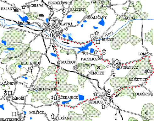
Buzice - Škvořetice - Sedlice - Čekanice
0.0 km
Go straight over the Míru Square. Cross the intersection and continue straight on the road to Buzice. The road is mostly
flat. Before Buzice, at the end of Buzice Pond, turn right across the bridge.
Buzice
Buzičtí from Buzice are mentioned already in 1384; after 1491 Buzice were sold to Blatná. The fortress was founded in
1384–1412. The four-story tower is from the end of the 14th century, the residential wings in the east and south were rebuilt
in the 16th century. The moats with the remains of the corner bastion are preserved in the south-eastern part. Already in
1527 was mentioned a fortress in Buzice. Start following the red trail. Before Buzice fortress turn right on a dirt road towards
Pacelice. On the right side there will be ponds along the whole ride until you reach the village of Pacelice. The village
Pacelice was first mentioned in 1380, later it became the seat of the rulers of Mirotice. The Church of the Transfiguration
of Jesus on the hill Křesovec (493 m) above the village was built in 1764–65, architecturally one of the precious buildings
of the trail by K.I. Dienzenhofer. The tower is later, from 1845. Farmhouses in villages no. 2 and 3 are from the mid-19th
century.
5.4 km
Above the village rises Křesovec hill. A red trail leads over this hill. At its peak stands an abandoned church built according
to the project of students of Kilian Ignatius Dienzenhofer. Go back to the road and follow it to Škvoretice, the red trail
leads along this road. On the right side of the hill called Hradiště was a large burial ground from the Bronze Age. In 1887
it was destroyed by an amateur excavation of the treacherous Baron Koller.
Švořetice
Already in 1299, tithes of the village were paid to the church in Mirotice. The fortress stood there sometime in the 14th
century. In the second half of the 15th century, the fortress, courtyard and part of the village were acquired from the Kalenický
of Kalenice Štenberks. The fortress was rebuilt in the Renaissance style in the 16th century and at the end of the 19th century
the desolate building was restored in a romantic style. At the end of the village is the Chapel of Our Lady of Sorrows, built
on the site of an older building. Near the village in the locality Hradiste is a large prehistoric burial ground.
6.9 km
From Škvoretice take the road towards Lom. The road runs through rolling countryside between fields.
10.1 km
At this intersection, which is within sight of the village of Lom, turn right towards Sedlice. Sharp climbs alternate with steep descents. Pass through the village of Důl and climb to Mužetice.
13.2 km
In Mužetice near the wayside shrine from 1862 you will encounter a green tourist trail. This will lead you right to the unpaved road towards Mužetický vrch. It is the highest point of Blatná region - altitude 573 meters. The green trail disappears from time to time, we have to keep right when choosing possible routes. Mužetický Hill is not forested and therefore it offers a nice view and you can see even Šumava. Go back down the green trail on the road. Then turn right and go in Sedlice. In the forest you will pass the parquet factory and pig farm on the right side. In Sedlice, a green trail will take you around a nicely restored church on the square.
Sedlice
The settlement Sedlice, situated on the southeast slope of the Brdy projection separating the Blatná basin from the Horažďovice basin, belonged to the old agglomeration of Bozeňsko ("Provincia Bozenensis") included the area of Blatná, Březnice and Rožmitál regions. It was settled before the other regions which is proved by the continuity of prehistoric and medieval settlement. The development of further settlement can be expected in the period of internal colonization (13th - 14th century), when along the old sand road was constructed an agricultural settlement. In the written sources, the settlement Sedlice (Sedlecz) was mentioned between 1352–1399 among the housing estates in the Bozeňov deanery. Sedlice was owned by the Bavarian family of Strakonice - Vilém of Strakonice is mentioned in 1358 as the patron of the church in Sedlice, which was already a parish in the 14th century. In 1404 Břeněk of Strakonice sold sedlice estates, i.e. the fields with the court and with the right of service to Vojtěch, Jan and Lipolt of Kraselov. At the time of the Hussite wars, Sedlice remained, like the whole region of Blatná, spared from war disasters. Probably from the second half of the 15th century Sedlice belonged to Nicholas Kaplíř of Sulevice. Further written reports are from the beginning of the 16th century. In 1505, the owner of Sedlice was Mikuláš Malovec of Pacov, who owned the estate in 1533. His son Jan sold the stronghold in Sedlice, the courtyard and the village with the right to lodge and other property to Adam Řepický of Sudoměř and thanks to him Sedlice was promoted to a small town. Adam Řepický survived his children, died in 1551 and Sedlice was taken over by his sister Kateřina, married to Zdeněk of Štenberk. In 1577, Sedlice was divided between her five sons and then Adam apparently bought all their shares and owned Sedlice until his death in 1623. Interesting is the contract of 1577, which emphasizes that despite the division of the estate, in common property remained the kitchen, pantry, courtyard, lifting bridge, worm staircase and gallery to the rooms, fountain in the ditch and ditches with water. The fort in Sedlice, built in 1404, was rebuilt in the second half of the 16th century into a Renaissance mansion with a rectangle moat. The core of the building is a two-storey building with two side wings. On the facade are visible remains of sgraffiti. The corridor is vaulted with a cross vault with walled arcades. Sedlice was the property of the Štenberks until 1708, who called it "good hen" because its profitability contributed to the multiplication of their property. The church of St. Jacob, the work of Václav Antonín Jermář dominates this part of Blatná. There is also the cemetery chapel of the Virgin Mary; the mortuary in the cemetery is from 1707. There are also interesting houses no. 159, 93 and 130 which has a façade with an attic with vases and a shield with a lying lioness from terracotta.
18.9 km
After a tour of Sedlice follow the road towards Blatná. Already in the town be careful not to miss the left turn to Čekanice. On a narrow road cycle through a slightly undulating landscape between fields until you reach Čekanice (see the 8th trail).
23.6 km
In Čekanice turn right. Behind the village climb a long hill. But do not worry, another descent to Blatná will be gradual and you will be rewarded by nice views of Blatná. On the right side you will go past the flooded quarry and then through the village of Mačkov.
27.4 km
After a long straight you will return to Blatná.
30.0 km
Blatná – Tower
Natural points of interest of the 7th trail
Along the entire trail you can admire a harmonious landscape with scattered forests, bushes and lonely trees. This type of landscape suits not only our eye, but also birds and roe deer and other game. Interesting birds nesting in shrubs are, for example, the Shrike and a rarer Great Grey Shrike. In Čekanice there is a nest of white storks on a high chimney. At the ponds Ovčín and Mokrý there are Bluethroat nightingale and reed warblers, reed bunting and other species of reed birds. Not far from Sedlice along the main road in the direction to Písek there is a nature reserve Sedlická obora, which protects the remains of natural oak beech and lime trees forests. The reserve is a part of the vegetation in a fenced inaccessible game park for fallow deer and boars.