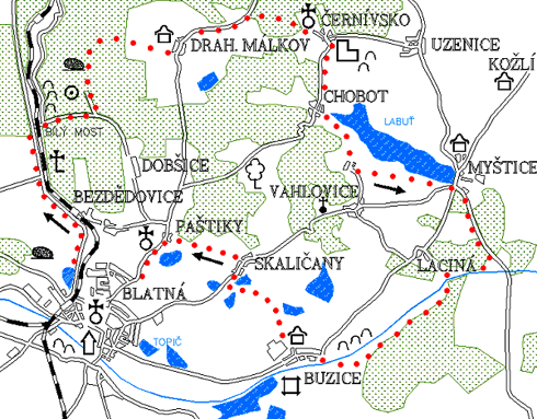
Černívsko - Labuť - Buzice - Paštiky
0.0 km
Set off at the square J. P. Koubka, go straight on towards the health centre where you turn left. At the crossroads at the railway crossing turn right on the road to Bělčice. On your right side there will be the railway line and the Závišínský stream. Pass the crossroads to Bezdědovice (right) and Chlum (left). Soon you will get to the edge of the forest where you will turn right to the forest road after a few hundred meters. Right at the turn there are well preserved mounds formed after panning gold (see route no. 1). Carefully cross the railway line and just behind it there is a stone bridge over the Závišínský stream. It's called Bílý most (the White Bridge).
4.8 km
There is a crossroad behind the bridge. Go straight on a narrow road up a steep hill. The path leads through a nice forest and still uphill.
6.4 km
On the ridge the road divides - going right you would reach the village of Dobšice. However, follow the ridge road on the left. On the left side, on Hliničný vrch, there is a cemetery from the Slavic era. Continue through the forest, after a while pass the wooden shack of the forest workers, followed by a slight climb. Just below the top, if you look carefully, you will see a stone standing on the left, it is called Mužík (the Little Man). The legend says that when Mužík descends to Dobšice, he will set the end of the world. Formerly it laid down for many years, but recently was erected again by the company Menhirostav. Continue along the ridge road and after a few hundred meters you will arrive at the crossroads.
8.0 km
The left road would take you to the village of Závišín, the direct one to the cottage settlement near Závišín. However, turn right along the bumpy forest road and will slowly descend to the village of Drahenický Málkov.
Drahenický Málkov
The first mention of the village is from 1454, when there was an independent farm. In 1552 the village was already part of the Drahenice estate. A farmhouse no. 9 with a gable of Baroque is from the mid-19th century, there was also an old pub in the village. In nearby Hostišovice there is a fortress from the 15th century, rebuilt in the Renaissance into a granary.
9.7 km
In Drahenický Málkov take the road to the left and cycle through the village. Behind the village, on the left there is a newly opened quarry. After a while the road will divide.
11.1 km
A sign of a green trail is attached at the intersection. Follow it turning right on the road. The road is not in good condition and at times is more like a bad forest road. But it goes through a nice forest. Soon you will see the church tower in Černívsko, which has been renovated recently. Above Černívsko there are ruins of the Křikava castle. Do not forget to visit them.
Černívsko
The village was first mentioned in 1352–1369, when it belonged to the Křikava castle. In the 15th century it belonged to Uzenice and from 1617 to the Drahenice estate. In 1770 there were three houses. The Holy Trinity Church is a 14th-century Gothic church, rebuilt in 1722. Above the village are the ruins of Křikava Castle, which are owned by the Knights of Dornštejn. In 1402 Křikava was conquered and plundered by Dobešík of Bor. In 1418, Jindřich Kolman of Dornštejn sold his last goods to Petr of Svojšín. Apparently, he also sold Křikava and from then on we do not have any more written mentions about it.
12.6 km
From the castle go back to the road and continue along the green trail. The journey is quite pleasant through the forest, without climbing.
Chobot
Originally there were two gamekeeper's lodges, in 1770 there were three cottages and two gamekeepers. At the beginning of this century almost the whole village burned down.
14.2 km
In the village of Chobot leave the road and follow the green trail through an unpaved road. On the left will be a nice view of the Labuť (Swan) Pond. Go through the village of Střížovice and continue along the pond. The green trail will lead you to the village of Myštice.
Myštice
King Charles IV registered the village in 1348, originally as royal goods, to Huk of Dornstein, owner of the castle Křikava. In 1418 Myštice was sold as a village to Orlík. In 1492, King Vladislav agreed to make a new pond at Střížovice (Swan Pond with an area of 108.5 ha). In 1609 the village of Myštice is mentioned near the Blatná manor. In 1648 there were four cottages, a tavern and a mill. Currently, 430 people live here. A pub no. 7 at the pond dam is from the 17th century. The pub has an arched Gothic cellar and a wide plank staircase leads to the first floor. The enclosure wall and the way of securing from the courtyard prove defensive efforts against the assault.
18.0 km
Keep on following the green trail and you will have to climbing the road up a steep hill. Then be very careful on the way down. Green trail turns right into the forest, on a forest road. This is where you will be heading. After a while you will leave the forest and will cycle through the cottage settlement. Go downhill until you reach the Nový mlýn (New Mill). The mill building is maintained in good condition.
21.1 km
Cross the bridge over the Lomnice river and right behind it is a crossroads. Follow the yellow trail to the right. The forest
road leads along Lomnice, which winds nicely in these places. The road will take us to the village Buzice.
Cross the bridge over the Lomnice River, right behind it is a crossroads. Follow the yellow trail to the right. The forest
road leads along Lomnice. The road will take you to the village Buzice.
24.7 km
In Buzice (see route no. 7), at the end of a long straight village square, turn right onto the road. Go past the agricultural farm and take the alley to Skaličany. The road leads through a flat landscape, between fields and ponds. Soon you will see the village Skaličany on the right side. At the crossroads head towards the village.
27.3 km
In Skaličany (see route no. 1) turn left at the chapel between houses and climb the unpaved road. We will have a nice view of Blatná. Continue on the unpaved road and soon you will enter the forest. Go through the forest for a short time, then along the pond until you reach the village Paštiky. The tower of the well-known Baroque church rises in front of you.
Paštiky
The first written record is from 1352. Already in the 15th century a small Gothic church stood on a slight elevation above the village, the first written record of it dates to 1411 (plebanus in Passcziek) and proves that there was a vicarage (plebanie). According to the regional historian of Blatná J. P. Hille, already in 1380 there was a vicar Martin in Paštiky, in 1395–1412 Jan of Přešťovice, who had disputes with Bušek of Buzice. In 1436 is mentioned a pastor in Paštiky who complained about Jan of Rožmitál for damages caused to the pond. Since 1594 the pastor was already in Blatná and the church in Paštiky became a branch office. From 1747 to 1753 the old church was demolished and replaced by a new one according to the plans of Kilian Ignác Dienzenhofer. The uniform interior Baroque decoration is the work of the woodcarver Ferdinand Ublaker and the painter J.V Spitzer, also from the mid-18th century. The location of the church in the landscape on a high terrace with a double staircase and its architecture from the end of Dienzenhofer's life is a harmonious work of three outstanding Baroque artists of their time.
28.9 km
Above the village, in the distance of about 300 meters there is a flooded quarry. Pure but cold water between the rocks attracts to go for a swim. The road will take you back to Blatná. Initially there is a steep descent, then the path leads through a slightly undulating landscape. You cannot get lost because Blatná is visible from a distance.
31.4 km
Blatná – Tower
Natural points of interest of the 5th trail
From Bílý most (the White Bridge) over the Závišínský Stream (see the 2nd trail), the path rises through the largest forest complex in Blatná. On the ridge of Hliniční Vrch (Hliniční Hill), (536 m above sea level) there are nice beeches and firs in the otherwise mostly spruce forest. You are very likely to hear the forest songbirds, such as robin, regulus, wren, thrush, blue P.m.modularis, warbler, chaffinch, sitta europaea, and tit - great tit, blue tit, coal tit, marsh tit and long tailed tit. The calm atmosphere is only disturbed by intensive mining in the quarry above Drahenický Málkov. Rybník Labuť (the Swan Pond) is the largest in the Blatná region with its area of more than 100 ha and its catches are of course the richest. On the surrounding meadows nest the most common of the waning waders - the lapwing. From Mírč to Buzice leads a path along the Lomnice River, above which a beautiful kingfisher sometimes flies. Under the settlement Buzičky in burrows in a small sand quarry nest dozens of pairs of martins, do not disturb and destroy their burrows, they are the rarest of swallow type birds. By the farmhouse at the end of Buzice, there is a metal pole with a stork nest erected several years ago as an opportunity for a stork to begin building a nest on the pole of a power line.